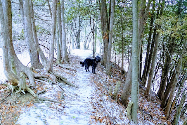
Cooper's Falls Trail near Gravenhurst

Hiking Muskoka

When we're able, we use our talents as hikers in Toronto to explore other parts of Ontario. This entry is one of the series from our October visit to Muskoka. 

Cooper's Falls Trail is a 7.3 hike each way and is located near Gravenhurst with beautiful lakes and the Canadian Sheild landscape. 

Vista views of lake on Cooper's Falls Trail

The Cooper's Falls Trail is part of the Trans Canada Trail that spans 27,000 km across Canada.

Cooper's Falls Trail is part of the Trans Canada Trail

There are no waterfalls on this trail, instead expect typical Canadian shield terrain and marshy ponds.

Canadian Shield on Cooper's Falls Trail

Expect to climb over large rocks that are typical in this part of Ontario.

Dog on large rock on Cooper's Falls Trail

The trail is mostly well marked with blue signs. We had some trouble finding the trail past Larroger Road.

Hiking trail marker on Cooper's Falls Tail

Parts of the trail are very muddy so wear appropriate footwear. 

Muddy areas on Cooper's Fall Trail

The leaves were still colourful during our hike, which made the scenery spectacular.

October view of Cooper's Falls Trail

We turned around halfway but met several hikers who trekked both ways.

Map of Cooper's Falls Trail in Gravenhurst

Parking

There are parking lots at each end: 

Links


For further information, see these pages:

Instagram

Enjoy your hike! When you post photos to Instagram, tag us at @hikingtoronto or #hikingtorontowithlucy.


Comments

Popular posts from this blog

Bestview Park Nature Trails

Sunnybrook Off-Leash Park

Bluffer Park and Marina

New Trails in Charles Sauriol Conservation Area

Huntington Park, Markham

Earl Bales Park to Don Valley Golf Course

Sherwood Park Off-Leash Paradise

Humber River Trail - Etienne Brulé Park

Rouge Park Woodland Trail

Colonel Danforth Park to Old Kingston Road