Posts

Showing posts from September, 2020

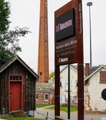
Todmorden Mills to Chester Hill Lookout
Image
Explore Toronto history by taking a hike through the Tordmorden Mills Heritage Site. If you've travelled on the DVP, you've likely noticed the iconic tower. The route I recently discovered combines seeing the buildings of Todmorden Mills, hiking the trails on the site, as well as visiting the Chester Hill Lookout and a few places along the Lower Don Trail. This might seem ambitious, but we did all of this about 5 km. Parking At the bottom of Beechwood Drive off of O'Connor, there is a free parking area near the entrance of Toronto Police Dog Services. Suggested Route The route I suggest begins on Beechwood Drive. Walk south on the Lower Don Trail to Pottery Road. After crossing the street, turn left on Pottery Road to the entrance of Todmorden Mills Heritage Site. Visit the historic buildings and hike the trails up to Broadlands. Walk to Chester Hill to the Lookout.  Autumn Vibes The trails are beautiful in September and October as the days get shorter and the foliage gets

Humber River Trail - Etienne Brulé Park

Image
The Humber River is 100 km long, so there are many hiking trails to explore.  The river connects to Lake Ontario in the south. See earlier blog entry, Sunnyside Beach , about a park to explore at the southern point of the Humber River. Parking or Transit This hike begins at the  Etienne Brule Park , where there is free parking. For those who use transit, the nearest subway station is the Old Mill Station . You'll be following part of the Humber River Recreational Trail.  Suggested Route Starting at Etienne Brule Park, walk north on the paved path until you reach the footbridge over the Humber River. Turn back at this point for an 8.5 km hike.  The Trail You can walk the paved trail for the entire hike if you like. There is also a gravel path as well as a footpath next to the river. Cyclists tend to use the paved path and joggers the gravel path.  I like to use the river path to get the best view of the birds, and for Lucy to play in the river. Weir or Low Head Dams The barrier that

Cedar Trail in Rouge National Urban Park

Image
The Cedar Trail has become my favourite hike of Rouge Park. The path has less traffic than the Vista or Orchard trails and takes you from a pond through a forest to the river with plenty of opportunity for off-leash play, birdwatching, and wildlife spotting. Lucy was able to be off-leash for most of the hike as we encountered very few people.  Suggested Route The hike is about 6 km in length, including the walk to and from the parking area to the trailhead.  Parking Park on the road near the Rouge Valley Conservation Area . Walk down the service road towards the Cedar and Orchard Trails. There are signs at the trailheads, so avoid the temptation to follow one of the side trails for now. The Pond The Cedar Trail begins with a walk along the pond. This is where you're likely going to see a lot of wildlife. On one visit, we encountered staff from the Toronto Zoo, releasing painted turtles in the pond. They were quickly welcomed into the habitat by the locals. Birdwatching Belted Kingf