Posts

Showing posts with the label 3 km loop

Rouge Park Woodland Trail

Image
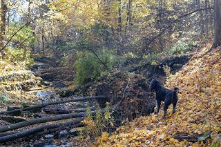
The Rouge Park Woodland Trail is one of the lesser-known trails in the Rouge Urban National Park.  Several trails take you through a beautiful forest and along the Little Rouge River. The 2 km trail is marked with green signs. The longer trails are not marked but are easy to find. Parking The parking area is located at 19 Reesor Road . The lot is small, so if it's full, see if you can find a spot on the shoulder of Reesor Road. The Trail Our actual 3 km route is shown in the map from the UnderArmor MapMyWalk App. If you use this app, find our route:  https://www.mapmywalk.com/workout/5069365768 The longer 5 km route takes you up a steep hill to a flat area closer to Reesor Road. If you use this app, find our route:  https://www.mapmywalk.com/workout/4991115811 The beginning part of the trail is lined with rocks. Well-worn footpaths follow the river. Be careful as the trail is very close to the riverbank that is eroding. You'll get great views of the river with a few spots...

Torrance Barrens Conservation Reserve

Image
Hiking Muskoka In October, we spent two weeks hiking trails in the Muskoka region. This entry is part of that series. Torrance Barrens is a great trail that was recommended to us by local hikers. On a Sunday morning in October, the parking lot was completely filled, so this is a well-known trail. Even with a full parking lot, we rarely encountered other people on the trail. The area is extensive and people walk the trails at different speeds. Parking The official parking lot is on Southwood Road, Gravenhurst .  Portable toilets can be found at this location. We noticed cars parked on other sections of the road, so there are many access points.  One of the first things I noticed about this trail is the secondary name "Dark Sky Reserve." A sign at the trailhead gives more information. For the past year, I've been working with the Space Place Canada team to bring a planetarium to Toronto. One of the things that Toronto is short of is a dark sky. The Torrance Barrens Dark Sky...

Moore Ravine - David Balfour Park Loop

Image
It's hard to believe that there are ravines like this in the middle of Toronto. Surprisingly, it took me so long to blog about this route.  The hike encircles the Rosedale and Moore Park neighbourhoods with Yellow Creek on the west and Mud Creek on the east. My delay in blogging about this hike is two-fold. There is ongoing construction in the Rosehill Reservoir and David A. Balfour park affecting the trail on the west side. Hikers can still use most of the trail, but some of the access points are closed. Secondly, if you don't live within walking distance or use transit, there are very few free parking spots. Suggested Route I parked at the Rosehill lot and began a 10 km hike at the David A. Balfour Park entry point on Avoca Ave. Walking south, follow the trail to the left to Evergreen Brickworks. Join the Beltline trail that takes you through the Moore Ravine to the Mount Pleasant Cemetery. Join the trail back into the ravine along Yellow Creek to the access point to the Davi...