New Trails in Charles Sauriol Conservation Area
A favourite trail has become even better! For the past few years, construction equipment has been on the south end of the Charles Sauriol Conservation Area. The construction is now complete, and the new trails connect even more neighbourhoods to this popular area of Toronto.


This is an excellent spot to watch the birds that migrate through Toronto. We've seen great blue heron, sandpiper, grosbeak, cardinals, sparrows, cedar waxwings, woodpeckers, finches, warblers, and more.


The Don Valley Parkway is on the other side of the river, so the trail is only truly quiet when the highway is closed.


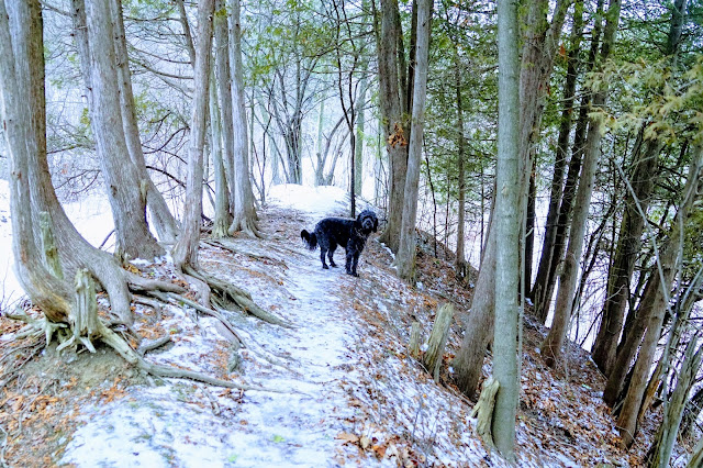
A switchback was built into the trail to reduce the steepness of the hill.


Instagram
The paved trail was originally from Lawrence Ave in the north to Wynford Drive in the south. Now you can follow paved trails to Wigmore Park or Anewen Greenbelt. Hiking from the Lawrence Ave parking lot to Wigmore Park is 3 km, so an in and out hike is a very pleasant 6 km.
Normally the parking lot and the trails are not maintained over the winter months. However, with Covid-19 still causing havoc, the city has decided to maintain trails this winter to allow people to get outdoors to get exercise and stress relief.

If you are new to this hiking area, maybe you have seen the rainbow tunnel driving on the DVP. This tunnel connects Moccasin Park to Charles Sauriol Conservation Area. There is a parking area in Moccossin Park as well. Read our blog about this trail Charles Sauriol and Moccasin Park.
This 6 km route can be viewed on the UA MapmyWalkApp: https://www.mapmywalk.com/workout/4980196852.

Parking
There are many parking spots at the Old Lawrence Ave entrance. This is the site of the Milne House that was built in 1871. You can read more about the history of this area in the Hiking the GTA Blog.
Conservation Area
When hiking in a conservation area, you have the opportunity to observe plants and animals in their natural habitat. Near the trailhead are signs for the Toronto Bird Flyways, interpretive signs to understand the region, and a seating area overlooking a pond.


eBird Canada is an online resource that allows people to record the birds they've seen in the area.
Past the pond is a seating area along the Don River. This is one of the spots where you can see salmon migrating up the river in September and October.

If you turn right at the first bridge, you'll see the popular rainbow tunnel. This is an excellent spot for photo opportunities and leads to the Moccasin Trail. For more information on this trail, see our blog entry, Charles Sauriol and Moccasin Park.

To access the new trails, keep on the main path going south under the train trestle.

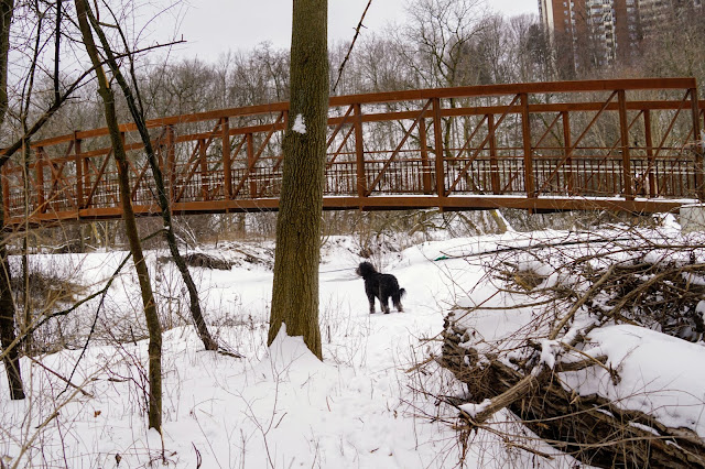
The next bridge on the trail is one that I photograph often. It looks interesting in every season and is another common spot for heron or salmon sightings.

Although the trail is finished, there is still work being done on the park train bridges.
New Trails
There is a large open area that marks the beginning of the new trails. If you go left over the bridge, you're in new territory.

If you turn right, you'll access the steep trail to Wynford Ave. This part of the trail is still under construction but is open when workers are not present.

The Don River twists and turns in this part of the park, so much of the construction work entailed building the bridges that cross the river multiple times.

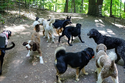
In between the bridges, there is space to play with friends you encounter along the way.

The trail takes you under another train bridge that is under construction.

And then there's another bridge over the Don River.

In this part of the trail, they've added seating areas where you can rest and visit with friends. The forest is thick and mature in this section, so there are opportunities for wildlife sightings.
The next section is a bridge followed by a boardwalk followed by another bridge. I'm not sure why it was engineered this way, but the fences and bridges make it harder for people to visit the forest and river, but hopefully, wildlife is not blocked.


The next part of the trail is fenced on both sides. I'm not sure of the rationale for the fences, but there are rails, so perhaps it's to help people walk on the steep trail, which is slippery at times.

You'll see side trails on both sides of the path in this area. Signs have not been erected yet, but I have explored every trail.

The one on the left takes you to the Anewen Greenbelt which is a large open area that leads to nearby neighbourhoods. The side trail on the right-hand side goes to the river and then ends. Trails are being built on both sides of Eglinton Ave, so perhaps this trail will eventually connect with the trails near the Flemingdon Park Golf Course.

The last stretch of the new trail takes you up a hill. The trail is fenced on one side.

And finally, you'll be at Wigmore Park. The walk was just under 3 km from the Lawrence Ave parking lot with plenty of hills to climb, rivers to cross and things to see.
Offleash Opportunities
Letting your dog off-leash on this trail depends on your dog's recall ability and the number of people on the trail. I often use the unpaved trails to let Lucy run free.
Trail extensions
There are several side-trails that can be explored if you want to make your hike longer or more rustic.
From the Lawrence Ave parking lot, we've hiked north along the Don River to the Donalda Golf Course. From a side trail after the last bridge in the new area, we hiked south all the way to the Taylor Creek Trail near E.T. Seton and the elevated wetlands. We've explored the old foot trails through the Anewen Greenspace area. We've explored both sides of the river through the entire park. If you have the time and desire, there is much to explore.
From the Lawrence Ave parking lot, we've hiked north along the Don River to the Donalda Golf Course. From a side trail after the last bridge in the new area, we hiked south all the way to the Taylor Creek Trail near E.T. Seton and the elevated wetlands. We've explored the old foot trails through the Anewen Greenspace area. We've explored both sides of the river through the entire park. If you have the time and desire, there is much to explore.
Enjoy your walk! When you post photos to Instagram, tag us at @hikingtoronto or #hikingtorontowithlucy


Maybe the fences are to protect wildlife from the hundreds of unleashed dogs, which destroy ground nesting birds and damage delicate native plants. Please keep your dog on a leash in wild areas.
ReplyDeleteI love the new trail however the old dirt trail had a certain appeal as well. So many trees were cut down in the process which is sad.
ReplyDelete