New Don River Trails - Taylor Creek to Flemingdon Golf Course
If you're looking for the least used trail along the Don River, this has to be it.

The Don River East flows through the parkland south of Eglinton Ave between the Don Valley Parkway and Bermondsey Road. User-created trails have been used for years, but the city is finally building official trails with bridges and eventually a safe way over the train tracks.

Since the trail is still under construction, you may not be able to access it while work is being done. Also, the details in this blog will be out of date once the trail is finished.

Charles Sauriol Conservation Area
According to a label on Google Maps, the section of the East Don River trail between Taylor Creek and Lawrence Ave is part of Charles Sauriol Park.
You may have noticed the monument to Charles Sauriol in the E. T. Seaton parking lot just north of the elevated wetlands. Presumably, there will eventually be a continuous hiking trail along the Don River from forks north to Lawrence Avenue.


There are unofficial trails along the river that connect the parks. We followed the trails and found them to be a bit of a mess around Eglinton Ave, largely because of the Crosstown construction.

Access to the trail
There are numerous access points to the new trails. Since this trail isn't officially open, I'll describe my experience accessing the trail with full knowledge that most people will likely want to wait until the trails are completed.
E.T. Seaton Park Area 2
The E. T. Seaton Parking area is the most southerly point of the trail and likely a common starting point for most hikers. On one of our visits, we saw a group of hikers who started from this point.

Be sure to stay on the Don River's east side if you start the hike from here. There is a trail on the west side, but it ends at Don Mills Road.

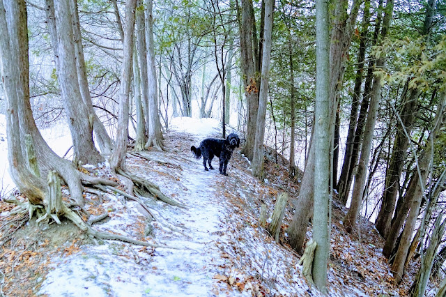
The trail is an old road, so it is flat and wide and follows the river's east side pretty closely.

The last time we passed through the area, there were piles of bridge pieces on the side of the road.

Not far away, you'll come to the unfinished bridge.

The temporary bridge that was next to the unfinished bridge has been dismantled. Hopefully, that means that the new bridge will be completed imminently.
This is the spot where you come to if you accessed the trail from Northline Road.
You can also access the trails in the ravine from Northline Road.

Park at the Toronto City Sports Centre on Northline Road, off of Bermondsey Road.

After parking, cross the road, and you'll see a trail down to the ravine. The trail is steep, so wear spikes in the winter to avoid falling.

The trail has several boardwalks built into the trail to avoid wet sections. I’m not positive, but I think this trail was created by cyclists looking for challenging off-road rides.

You'll end up reaching the river just south of the unfinished bridge. The temporary bridge was recently dismantled, so if the new bridge isn't finished, you'll only be able to walk south to Taylor Creek or E. T. Seaton.
Linkwood Lane Dog Park
This is a common entry point for residents of the apartment buildings near Spanbridge Road. If you don't live in the apartments, park on the street and follow the trail that takes you into the ravine. Note that the hill is pretty steep, so wear proper footwear.

You'll reach the river, where your only option is to go north over the bridge, heading towards the golf course. If you want to go south, there is a train track that must be crossed to reach the trail to Taylor Creek. This is where a tunnel is needed to connect the north and south parts of the trail.

Many people choose to go over the tracks based on the footprints in the snow and the neatly cut fence.


We came on a day when the river was frozen, so we walked on the ice under the bridge.

After crossing the tracks, there is a choice of taking a road-like trail or a foot trail through the forest next to the river. Both trails take you to the previously mentioned unfinished bridge.

Victoria Village Arena
This is the most straightforward entry from the north end and most likely will become the official trailhead and parking lot.

After parking at the far end of the Victoria Village Arena parking lot, walk to the street and turn right on Bermondsey Road. Pass the driveway for the Bermondsey Transfer Station and turn right into the next driveway.

On your way to the start of the trail, the road takes you past a hydro field, a meadow, and a busy garbage facility.

We met people who drove a 4x4 vehicle to park at the bottom of the hill. No signs indicate that you can't park there, but I've often seen railroad employees parked in this area.

If the employees are there, the gate will be open. Otherwise, use the unofficial opening in the fence and cross the tracks.

You'll reach the river at the south end of the Flemingdon Golf Course. From here, you can explore the golf course when golf is not in season. We've seen people walking dogs, snowshoeing, and skiing on the golf course.

To explore the new trails, stay to your left and head south. You'll be able to see the first of the new bridges.

Cross the bridge to get to my favourite part of the new trail.

An outdoor shelter has been created where you can sit by the river and relax.


This bridge is actually two bridges with a fenced-in connection.

Crossing this bridge brings you to the spot mentioned earlier with the elevated train tracks. The train tracks are crossable, but it's not ideal. While researching, I found plans for a tunnel to connect the north section to the south section.
The plans didn't have a date for when the work will start or finish, but my hope is that the work will be done in the summer of 2021 so more people canenjoy this important new hiking trail.
Distance
The distance of the hike depends on the entry point and how far you choose to go. It's an in and out hike, so you can choose to turn back whenever you like. Walking from the arena to the third bridge and back was just over 5 km. Hiking to the beginning of Taylor Creek and back will likely add 3 kilometres.
Birdwatching
We have seen a red-tail hawk, ducks, blue jays, and woodpeckers. I presume that the population of birds will increase in the springtime.
Enjoy your walk! When you post photos to Instagram, tag us at @hikingtoronto or #hikingtorontowithlucy


This comment has been removed by a blog administrator.
ReplyDeleteThe green is an extraordinarily especially manicured district incorporating the opening. The opening is the end focal point of a golf swing. I consider the green being the parking structure for my golf ball. Click here golf course cart path construction
ReplyDeleteI love this website. I don't have a dog though so I just carry a little plastic bag for my poo
ReplyDeleteThe bridges still need a ramp but otherwise they are open! awesome path if you want a quiet walk, just watch for mosquitos! lots of them closer to the creek!
ReplyDelete