Bestview Park Nature Trails
The parkland south of Steeles Ave between Bayview Ave and Leslie Street is a huge area with many trails. One trail follows the Don River, and another follows the tributary, German Mills Creek. The trails immediately behind the tennis courts are known as Bestview Park Nature Trails.
Parking
Park near the Steelesview Public School at 105 Bestview Drive. Park on the street or use the spots at the school when it is closed.

Suggested Routes
These trails are difficult to describe since none of them are marked. To make it clearer, I've separated the trail descriptions into three parts, as indicated by the numbers on the map.

Saint Joe's
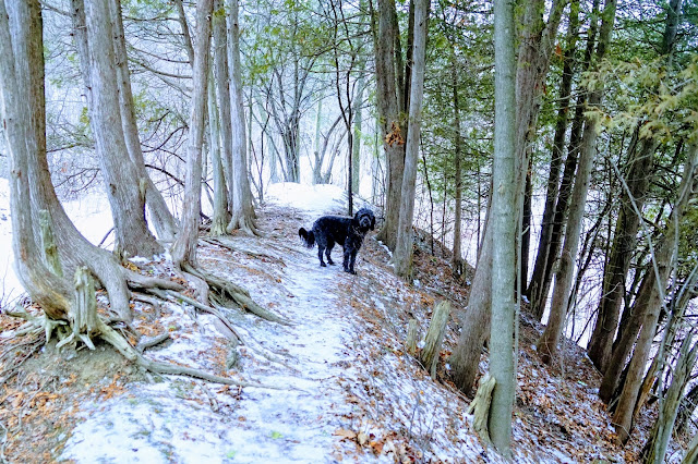
Turn right just before the bridge onto the unpaved trail to explore the trails along the Don River.


Continue along the unpaved path next to the river until you see the school across the river.

There is a bridge that crosses the river to the school property, but it is locked.
There is a bridge that crosses the river to the school property, but it is locked.
Return to the main path via the same trail along the river or if you want to have a chance to see deer, follow the paths between the river and the houses. We didn't see any, but there are many prints to indicate that they were there recently.

In the winter, it's easy to see the footsteps others have taken. It may be less obvious in other seasons, but you should be able to find a trail.

In the winter, it's easy to see the footsteps others have taken. It may be less obvious in other seasons, but you should be able to find a trail.
Off-Leash Opportunities
Of all the trails in this area, the trails along the Don River give you the best opportunity to have your dog off-leash.
To Cummer
When you get back to the paved trail, turn right and continue until you get to the Finch Hydro corridor. This paved trail uses the land below the hydro towers and is popular with cyclists.

The trail travels west until Highway 400. This is too far to hike with a dog, so instead, turn back the way you came to explore the trail to Leslie Street.
To Leslie
In my attempts to make a loop of these trails, I found that if you use the paved path towards Leslie Street, you can cross the footbridge over the creek and ravine to get to the Bestview Nature Trails.

When you get back to the fork in the path, stay on the paved path going to the right. This is the German Mills Creek, a tributary of the Don River.
When you get back to the fork in the path, stay on the paved path going to the right. This is the German Mills Creek, a tributary of the Don River.
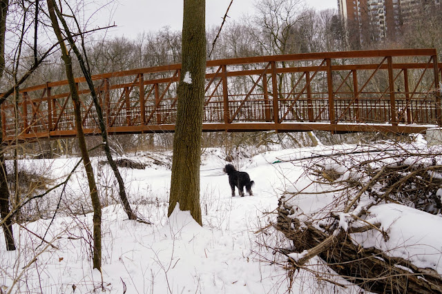
Follow the path north-east to Leslie Street, near Steeles Ave East. Before you come to Leslie Street, you'll see a massive overhead footbridge.

Climb the 50 steps to the top and cross the bridge over the ravine and creek. This bridge connects Pineway Blvd to Goldenwood Road.

Climb the 50 steps to the top and cross the bridge over the ravine and creek. This bridge connects Pineway Blvd to Goldenwood Road.
After crossing the bridge, follow the path down into the ravine. Follow the trail the creek to the Bestview Park Nature Trails.

Bestview Nature Trail
The Bestview Nature Trail is unmarked and not paved but takes you through a forest along the German Mills Creek. People use these trails all year round, so if you let your dog off-leash, be aware if others are using the trail as well. It is straightforward to follow the trails in the winter, but this area gets pretty overgrown in the summer.

A faded map is posted, but at best, it gives you a rough idea of the area.

A faded map is posted, but at best, it gives you a rough idea of the area.
The hills in this area can be steep, so use the staircase to make it easier to explore both parts of the ravine. On Google Maps, the staircase is labelled "Lady's Stairs."

Follow the trail to the tennis courts near the Steelesview School on Bestview Ave to complete the hike.

Actual Route
We hiked 8.5k by following all three trails with a loop back to Bestview Park, as shown. You can adjust the length of your hike by following only one or two of the sections. If you use the MapMyWalk app, you can follow the route we took: https://www.mapmywalk.com/workout/5340627631.

Trail Extensions
As mentioned earlier, the paved trail at Cummer continues west to Highway 400. Other extensions are possible as well.
Don River Trails
If you continue south past Cummer, you'll reach Finch Ave. There is an underpass where the trail continues to Sheppard Ave. See our post about the East Don Trail - Sheppard to Finch for details.
Duncan Woods Creek Trail
At Leslie Street, you can connect to the Duncan Woods Creek Trail and hike south-east to McNicol Ave. Watch for a future entry about this trail.
German Mills Settlers Trail
If you cross Steeles Ave near the Leslie trail ends, you can follow the German Mills Creek to the German Mill's Settler's Park. A blog about this park is coming soon.
Enjoy your walk! When you post photos to Instagram, tag us at @hikingtoronto or #hikingtorontowithlucy


Thank you for publishing this information. We are spoiled in Toronto with all this green space!
ReplyDelete